- Navigation & GPS[10]
- Auto Production Line Equipment[1]
- Wheel Alignment[2]
- Other Audio & Video Equipments[2]
- Electronics Production Machinery[2]
- LED Displays[1]
- Conveyors[5]
- Alarm[1]
- Set Top Box[4]
- Fixed Wireless Terminals[1]
- Other Telecommunications Products[1]
- Repeater[2]
- Telecom Parts[1]
- Wireless Networking Equipment[9]
- Walkie Talkie[10]
- Tool Box[10]
- Other Marine Supplies[9]
- Railway Supplies[1]
- Contact Person : Ms. Wu Liping
- Company Name : Tianjin 712 Communication & Broadcasting Co., Ltd.
- Tel : 086-022-65388698
- Fax : 086-022-65388646
- Address : Tianjin,Tianjinshi,Rm. 218-219, Syntheses Service Building, West Area, No. 19, Xinye Sixth Street, West Tianjin Economic and Technological Development Zone
- Country/Region : China
- Zip : 300462
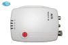
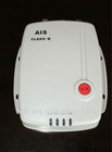
Marine Traffic GPS for ships and boats


Related Product Searches:Marine Traffic GPS for ships and boats,High Quality,Marine Traffic GPS, Boat AIS Class B,Class B
Marine Vessels AIS Class B System
This system is a Marine Electronic Chart Display and Information System, which is in line with related international standards, capable of using electronic chart in accordance with international standards for electronic chart production IHO S-57 and compatible with raster chart. Electronic chart can display real-time position and navigation information of all the vessels equipped with AIS Class A / B terminal. Update for electronic chart, client software and other operation can be carried out on line. The system, applied a multi-user and multi-authority management mechanism,can be used in monitoring center, marine transport management department, shipping service companies, etc.
The system provides multi-system mode for data sharing and also can reasonably optimize resources for users.
Overall logical structure:
Function Introduction
(1)Basic Function
1. Data Receiving & Sending:
static information and dynamic information of vessels
2. Electronic Chart Display
a)Display real-time location detailed Information of vessels: latitude and longitude, direction, status
b)Arbitrary to zoom in, zoom out, browse electronic chart and adjust direction and angle of electronic chart
c)Provision of multi-mode environment(day, night, cloudy day, etc)
d)Customizable interface and toolbar
3. Orientate and Search Vessels
a) Click on vessel icon or input vessel number to view information of vessels
b) Automatically measure and calculate the distance between two vessels
4. Early Warning Function
a) Drawing of dangerous area,fishing forbidden area,coastline border and other special regions
b) Automatic measurement of CPA and TCPA
c)Automatically measure and calculate whether ship will pass through dangerous areas and give warning if going to pass through
5.Track repeat function,track information import and export
6.Ships, crew, company basic information management
7.Data backup and restore
8.Performance management, security management, resource management
9.Log System
10.Set aside extension interface
(2)Extension function
1. Multi-user and multi-authority:Visit through C / S and B / S mode, each user has to operate according to authority rules defined by control center.
2. SMS dispatching:Single,mass,restricted area sending and broadcasting
3. No regulation mode:Automatic analysis of vessel’s path and real-time early warning will be written into log
4. Raster Charts:Compatible with the use of raster charts
5. Electronic Chart Update:Updated at any moment, support adding the label of explanation and information.
(3)Value-added features
1. Vessel Traffic Management System(VTS): display real-time information to achieve real-time monitoring management
2. Value-added multimedia services:
(1) Add GSM module: achieve value-added services, such as text message alert, login password revision, etc.
(2) Combination of soft-switched networks: provide value-added service such as network video conference, e-mail reminder, voice messages, voice e-mail, Internet telephone, video surveillance, etc.
3. Integration with other various monitoring systems: radar navigation subsystem, GPS
4. Three-dimensional figures: display more kinds of information in electronic chart through the Internet, such as offshore land information, weather information, marine resources information, ocean current information.
AIS Class-B Successful Case
During January to October, 2008, more than 5000 sets AIS products made by Tianjin 712 Communication & Broadcasting Co. Ltd. have installed on fishing boats in Zhoushan, which has successfully prevented occurrence of collision accidents.
Case1
At 9:50 p.m. on April 5th, 2008, a foggy day, when Zhejiang fishing boat 42115 anchoring at 122 degrees 36 minutes east longitude, 29 degrees 38 minutes north latitude, terminal in AIS Class-B marine automatic identification system used on fishing boat sent out distance alarm as a merchant ship was coming close. The alarm informed the ship crew, most of whom were having rest , to evacuate in time. All 12 crew members were saved by nearby fishing boats. Above fact shows that application of this system can effectively prevent occurrence of major accidents.
Case 2
At 11:40 p.m. on February 27, 2008, Zhejiang fishing boat 42265 was wrecked by an unknown merchant ship at 122 degrees 52 minutes east longitude, 28 degrees 09 minutes north latitude and 9 crew members on board were all missing. Wrecker ship escaped. Then through AIS Class-B terminal SOS message with accurate accident location was sent out to nearby boats. After receiving report of the accident, Ocean and Fishery Bureau in Zhoushan immediately take rescue actions and tracked suspicious ships according to vessel’s trace in system’s platform. The wrecker merchant was caught due to AIS Class-B terminal’s cooperation with Ocean and Fishery Bureau’s in-time dispatching of fishing boats, coordination of the maritime police boats and sea plane’s monitoring.
Marine Traffic GPS for ships and boats